
Preview
Description
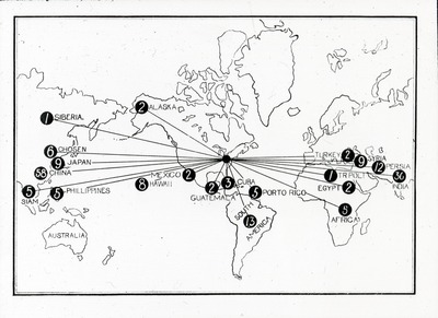
A world map, with multiple lines directed outwards from a center-point over Ohio. Each point is marked with a number enclosed within a black dot. It is possible that these numbers represent the number of missions active in a given location. This image comes from a collection of ten slides pertaining to Wooster missions.
Subject
Religious order series; Charts, diagrams, etc; College graduates; World maps
Creation Date
1914
Format
JPEG 2000
Source
The College of Wooster Special Collections
Relation
This is one of 49 Lantern Slides in the Buildings and Grounds Collection.
Keywords
world map, Wooster Missions, Wooster Alumni
Keywords
world map, Wooster Missions, Wooster Alumni